I’ve attempted Middle Palisade 3 times and summited once. This is the story of my third attempt in September 2023. Read till the end to see if it was #SummitSunday.
If you aren’t familiar, Middle Pal is a 14er (a 14,000+ ft high peak) and one of the tallest points in California that can be scrambled up without speciality equipment. The easiest way to get up is an unmarked, exposed, requires-hands-and-feet climb, a little spicier than your average AllTrails hike. It’s rated 3rd class.
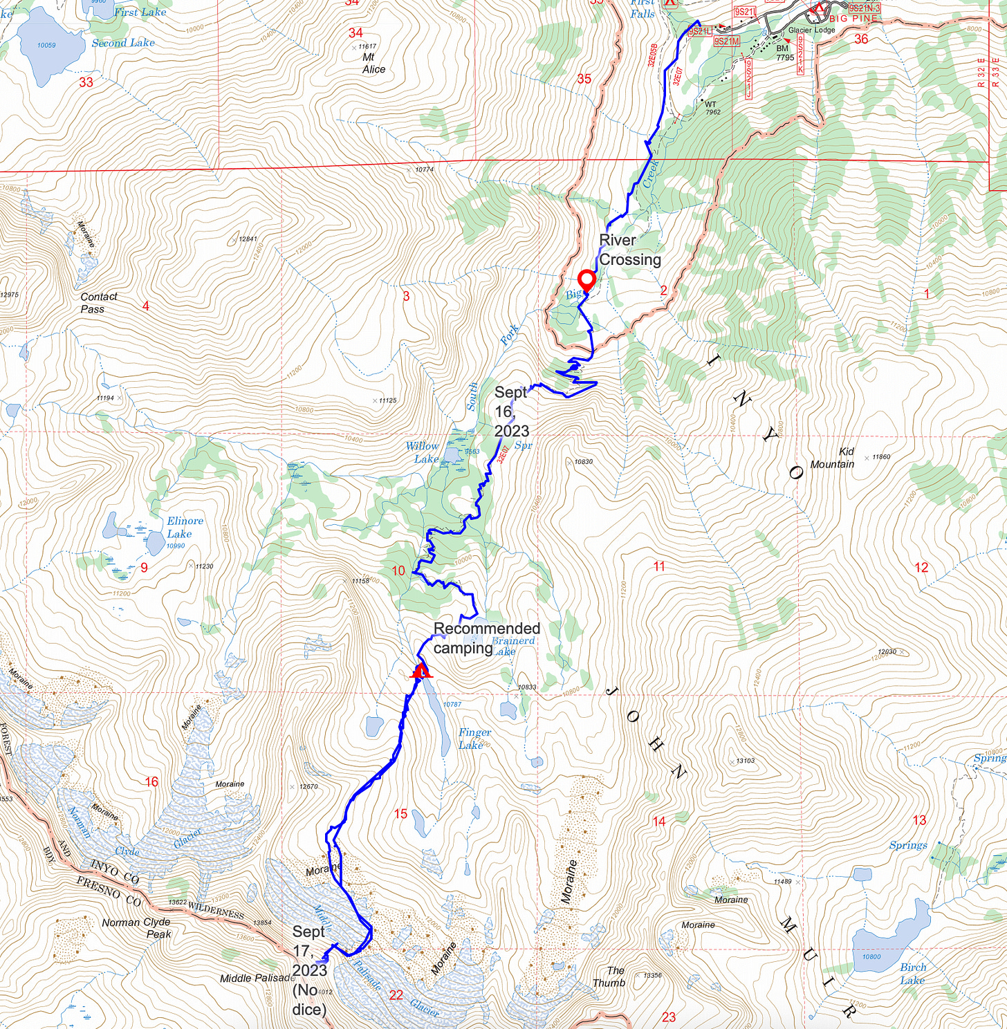
On our first day, we backpacked to Finger lake. A couple of miles in, the trail crosses over South Fork Big Pine creek, teeming with water from the 60 feet of snow the Sierras received this winter. It was a chilly, thigh-deep wade. Afterward, an 8 lb pet dog crossed, ears back and trembling. It was a good reminder that I had actually signed up for this.
The maintained trail stops at Brainerd lake and then a used trail, comprising a couple cairns and some sandy footprints and many boulders, gets you to Finger lake. Cairns, for reference, are human-made stacks of rocks used to signify a trail, and they are typically visible from 5 to 15 feet away. The sun was going down as we got to Brainerd, making for some spicy cairn hunting. But it was all worth it when we arrived at Finger lake, one of the most beautiful Alpine lake, with the soft light of sunset.
The next morning we began our summit attempt of Middle Pal. Just 30-50 feet from our campsite lay a tributary of South Fork, marking our first obstacle.
After crossing the river, we went up what felt like an infinite field of boulders. Two days later, the experience was cemented in my sore thighs (the only body part hurting from the trip). Unfortunately, our accommodation was an AirBnB with numerous stairs.
After the boulders, the glacier starts where I used crampons and an ice ax to cross (you can find a video below demonstrating the proper ice ax technique). Interestingly, when I reviewed my GPS track from two years ago, I noticed that I had crossed the same glacier, but back then, I didn't require any equipment because there was no snow.
After the glacier is probably the most annoying part of the climb which is the crumbling ridge—it’s the ole 2 steps up and slide 1 step down.
The next part is where I had previously turned back in 2019 since one of my friends was uncomfortable with the exposure. It’s called the “red band” and connects you to the face of Middle Pal.
After that, we began climbing up the face. While it remains exposed, there are secure footholds and hand placements throughout the climb and the views are breathtaking.
As we were going up, a climber from Mammoth passed us. Assuming that this climber must know what they were doing, I opted to follow their lead. This was a mistake. Instead of referencing my extensive notes and previous GPX route, I blindly followed the climber and found myself below a class 5 section, dislodging a large block of mossy rock. We decided to turn around. On our descent, we discovered that we had taken the wrong chute, violating the cardinal rule of never blindly following another climber.
We decided to not try to go up the other route as the temperature was dropping rapidly, and based on my past summiting experience, I knew it was challenging.
We didn’t get to the summit that day but we got very high, just below 14,000 feet.
We traced our steps back to camp and enjoyed some dinner and dessert oreos, where I learned that milk’s favorite cookies are vegan.

As I mentioned, I’ve done Middle Pal 3 times. First time, we turned around since someone in the group wasn’t comfortable. Second time, we reached the top but it was a long day with some class 5 moves. Third time, we followed someone up the wrong chute. 4th time is the charm as they say.
Trip Planning
Resources:
https://caltopo.com/m/29BTG - GPX with all my previous routes (along with which ones were successful). If you’re coming from the bay area, I recommend splitting it up into Day 1 go to Finger Lake, Day 2 summit and Day 3 hike down.
Before you leave:
Read everything you can on the route & download the GPX, pictures of key section and previous summit reports.
Check the weather on Middle Pal
Check the air quality
Check for the latest information (water crossing, snow, rock quality)
If want to overnight backpack, get the “Big Pine Creek South Fork” permit here. This is very popular permit FYI.
Advice:
The river crossing - If you go up the trail 100 ft or so, the crossing gets wider and becomes ankle deep to cross. We didn’t see this till the way out.
The glacier crossing - I used an ice ax and crampons to navigate the glacier. One person in our group used an ice axe and microspikes and another used nothing.
The climb
I wore regular tennis shoes and a helmet. I think next time I might bring climbing shoes. If you bring rope, I recommend bringing some trad gear since there aren’t a lot of rocks to sling.
For the route, I recommend taking red band and then staying left to get to the leftmost chute like I pictured above.


Summit or not, this is total badassery and I love it!